Ficheiro:Outre-mer en.png
Tamaño desta vista previa: 800 × 400 píxeles. Outras resolucións: 320 × 160 píxeles | 640 × 320 píxeles | 1.480 × 740 píxeles.
Ficheiro orixinal (1.480 × 740 píxeles; tamaño do ficheiro: 54 kB; tipo MIME: image/png)
| Este ficheiro procede de Wikimedia Commons. A continuación móstrase a información da súa páxina de descrición. Commons é un repositorio libre de ficheiros multimedia. Pode contribuír alí cargando as súas imaxes. |
Resumo
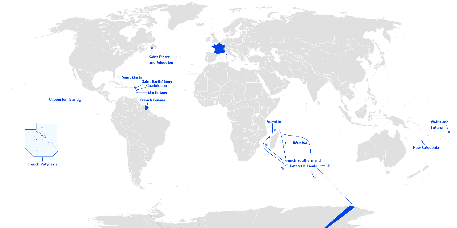
English: This is a translation from esperanto (by Hoshie) into english of User:Manchot sanguinaire's map of French Overseas départements, regions, collectivités, and territories, which is at Image:Outre-mer eo.png. The translations of the names into english are the names used in the CIA World Factbook. I also also added the five Îles Éparses that surround Madagascar. The source for their placement on the map is the CIA Factbook map of the area, which is here on Commons at Image:Iles Eparses-CIA WFB Map.png. The placement of Adélie Land is based upon Image:Antarctica territorial claims.png by User:Astrokey44. Since the original map is GFDL, this one is too.

|
Esta imaxe (ou todas as imaxes deste artigo ou categoría) deberían volverse crear como imaxes vectoriais SVG. Isto proporciona moitas vantaxes, véxase Commons:Media for cleanup (en inglés) para máis información. Se xa hai unha versión SVG desta imaxe dispoñible, por favor, cárguea en Commons. Tras subila, substitúa este modelo polo modelo {{vector version available|novo nome da imaxe.svg}} nesta imaxe.
|
Licenza
Hoshie, como posuidor dos dereitos de autor desta obra, pola presente publícaa baixo a seguinte licenza:

|
Autorízase a copia, distribución e/ou modificación deste documento baixo os termos da licenza de documentación libre GNU, versión 1.2 ou calquera outra que posteriormente publique a Free Software Foundation; sen seccións invariables, textos de portada, nin textos de contraportada. Inclúese unha copia da devandita licenza na sección titulada GNU Free Documentation License. |
| Este ficheiro está licenciado baixo a licenza Creative Commons recoñecemento compartir igual 3.0 sen adaptar. | ||
| Recoñecemento: Hoshie | ||
| ||
| A etiqueta desta licenza engadiuse a este ficheiro como parte da actualización da licenza GFDL. |
Historial do ficheiro
Prema nunha data/hora para ver o ficheiro tal e como estaba nese momento.
| Data/Hora | Miniatura | Dimensións | Usuario | Comentario | |
|---|---|---|---|---|---|
| actual | 27 de marzo de 2018 ás 20:27 | | 1.480 × 740 (54 kB) | Maphobbyist | Upload |
| 28 de febreiro de 2016 ás 09:12 |  | 1.480 × 740 (54 kB) | Kontrollstellekundl | Polynesia colour | |
| 24 de xullo de 2013 ás 13:15 |  | 1.480 × 740 (44 kB) | DrKay | remove dark grey areas in Antartica, Dniestr, Kosovo, Palestine, etc. | |
| 12 de febreiro de 2012 ás 20:41 |  | 1.480 × 740 (75 kB) | Spesh531 | +south sudan, antarctic territories, other lands, change color of land, fixed boudaries, added accents on e in R e union and Saint Barth e lemy, fixed islands in French Polynesia | |
| 17 de decembro de 2007 ás 03:12 |  | 1.432 × 742 (58 kB) | Rosss | More accurate shape for French Polynesia | |
| 22 de abril de 2007 ás 02:44 |  | 1.432 × 742 (39 kB) | Kelvinc | fixed shading of antarctica east of adelie land | |
| 17 de abril de 2007 ás 09:59 |  | 1.432 × 742 (26 kB) | Tene~commonswiki | Optimised (0) | |
| 5 de marzo de 2007 ás 14:14 |  | 1.432 × 742 (60 kB) | Hoshie | added Antarctica itself to the image and marked the French claim. The position of St.-Barth and St.-Martin has been fixed | |
| 4 de marzo de 2007 ás 18:26 |  | 1.357 × 628 (53 kB) | Hoshie | removed labels for the Iles Eparses, since they are a part of the TAAF; see http://www.taaf.fr/rubriques/iles/iles_introduction.htm | |
| 2 de marzo de 2007 ás 07:11 |  | 1.357 × 628 (54 kB) | Hoshie | fixed map to include St.-Martin and St.-Barth. |
Uso do ficheiro
A seguinte páxina usa este ficheiro:
Uso global do ficheiro
Os seguintes wikis empregan esta imaxe:
- Uso en af.wiki.x.io
- Uso en ar.wiki.x.io
- Uso en as.wiki.x.io
- Uso en az.wiki.x.io
- Uso en bcl.wiki.x.io
- Uso en be.wiki.x.io
- Uso en ca.wiki.x.io
- Uso en da.wiki.x.io
- Uso en de.wiki.x.io
- Uso en el.wiki.x.io
- Uso en en.wiki.x.io
- Portal:France/Geography
- Portal:France/Administrative divisions
- Template:Infobox European Parliament constituency
- Overseas Territories of France (European Parliament constituency)
- Template:Infobox European Parliament constituency/doc
- Overseas France
- File talk:Outre-mer en.png
- Template:Infobox European Parliament constituency/sandbox
- Uso en eo.wiki.x.io
- Uso en es.wiki.x.io
- Uso en et.wiki.x.io
- Uso en eu.wiki.x.io
Ollar o uso global deste ficheiro.