Ficheiro:OttomanEmpireIn1683.png

Tamaño desta vista previa: 637 × 599 píxeles. Outras resolucións: 255 × 240 píxeles | 510 × 480 píxeles | 816 × 768 píxeles | 1.088 × 1.024 píxeles | 1.966 × 1.850 píxeles.
Ficheiro orixinal (1.966 × 1.850 píxeles; tamaño do ficheiro: 298 kB; tipo MIME: image/png)
| Este ficheiro procede de Wikimedia Commons. A continuación móstrase a información da súa páxina de descrición. Commons é un repositorio libre de ficheiros multimedia. Pode contribuír alí cargando as súas imaxes. |

|
Esta imaxe (ou todas as imaxes deste artigo ou categoría) deberían volverse crear como imaxes vectoriais SVG. Isto proporciona moitas vantaxes, véxase Commons:Media for cleanup (en inglés) para máis información. Se xa hai unha versión SVG desta imaxe dispoñible, por favor, cárguea en Commons. Tras subila, substitúa este modelo polo modelo {{vector version available|novo nome da imaxe.svg}} nesta imaxe.
|
Resumo
| Descrición |
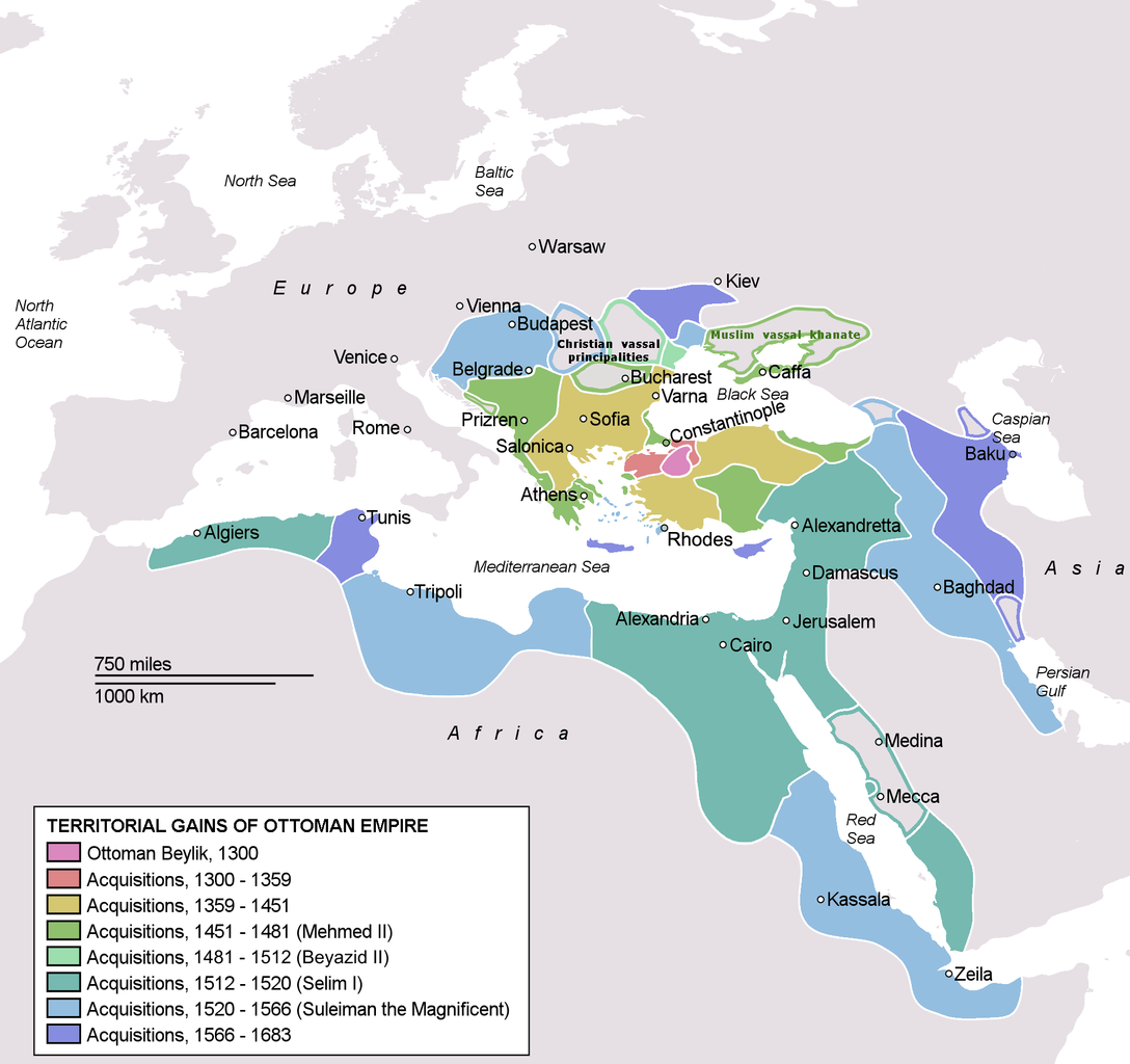
Deutsch: Karte des Osmanischen Reiches zum Zeitpunkt seiner größten Ausdehnung 1683.
Türkçe: Osmanlı İmparatorluğu en geniş sınırları (1683) |
| Data | |
| Orixe | Self drawn, mainly based on Robert Mantran (ed.), Histoire de l'Empire Ottoman, Paris: Fayard (1989), also en:List of Ottoman Empire dominated territories, Image:Ottoman 1683.png, [1], and [2]. Background map modified from Image:A large blank world map with oceans marked in blue.svg. |
| Autoría | Atilim Gunes Baydin |
| Outras versións |
[]
|


![[1]](http://fs.huntingdon.edu/jlewis/Syl/IRcomp/Maps/OttomanMap.jpg)
![[2]](http://www.morainevalley.edu/ctl/MiddleEast/images/Map_Ottoman_Empire_expansion_EB.jpg)
Licenza
| Eu, como posuidor dos dereitos de autor desta obra, libéroa para que pertenza ao dominio público. Isto é válido en todo o mundo. Nalgúns países, isto pode non ser legalmente posible; entón: Concedo a calquera o dereito de empregar esta obra para o propósito que considere oportuno, sen condicións, agás aquelas que sexan requiridas pola lei. |
Historial do ficheiro
Prema nunha data/hora para ver o ficheiro tal e como estaba nese momento.
| Data/Hora | Miniatura | Dimensións | Usuario | Comentario | |
|---|---|---|---|---|---|
| actual | 17 de setembro de 2020 ás 17:35 | | 1.966 × 1.850 (298 kB) | Visnelma | Adjusted eastern and balkan borders, also vassals are added. |
| 16 de setembro de 2020 ás 22:36 |  | 1.966 × 1.850 (296 kB) | Visnelma | African coast of Red Sea was painted purple by mistake, I have corrected that. Also Georgia was an Ottoman vassal. I have added that. | |
| 16 de setembro de 2020 ás 21:42 |  | 1.966 × 1.850 (296 kB) | Visnelma | Athens and Morea was conquered during the reign of Mehmed II. Odessa and Moldova was conquered during the reign of Beyazid II. Hicaz and Yemen was conquered by Selim I. The region that connected Ottoman mainland and Crimea was conquered during the reign of Suleiman the Magnificent as well as Georgia. The territory on Persian gulf which is extension of Iraq was conquered during the reign of Suleiman, Ottomans never conquered Circassia. Furthermore Podolia was conquered during the 17th century,... | |
| 31 de maio de 2014 ás 17:49 |  | 1.966 × 1.850 (369 kB) | Spiridon Ion Cepleanu | New rectification since H.-E. Stier (dir.): « Westermann Grosser Atlas zur Weltgeschichte », 1985, ISBN 3-14-100919-8, pp. 96, 97, 103, 112 (because the accuracy is disputed) but with a better appearence I hope. | |
| 6 de marzo de 2013 ás 17:58 |  | 1.966 × 1.850 (339 kB) | DragonTiger23 | Reverted to version as of 23:11, 10 December 2010 Returned the map to its original appearance. | |
| 4 de marzo de 2012 ás 19:47 |  | 637 × 599 (172 kB) | Spiridon Ion Cepleanu | Little changes since Hans-Erich Stier (ed.), Grosser Atlas zur Weltgeschichte, Westermann 1895, ISBN 3-14-10 0919-8, pp. 103, 103 & 112. | |
| 10 de decembro de 2010 ás 23:11 |  | 1.966 × 1.850 (339 kB) | Lambiam | Scale indicator more up to actual scale | |
| 16 de novembro de 2010 ás 18:53 |  | 1.966 × 1.850 (367 kB) | Hamelin de Guettelet | {{Information |Description= Rhodes et autres îles ne sont prises aux Hospitaliers que le 1 janvier 1523 |Source={{own}} |Date=16 novembre 2010 |Author=Hamelin de Guettelet |Permission= |other_versions= }} | |
| 1 de abril de 2010 ás 10:40 |  | 1.966 × 1.850 (327 kB) | Nedim Ardoğa | Reverted to version as of 07:37, 10 March 2010 | |
| 31 de marzo de 2010 ás 12:11 |  | 637 × 599 (165 kB) | Bahramm 2 | Reverted to version as of 14:12, 1 March 2010 |
Uso do ficheiro
As seguintes 2 páxinas usan este ficheiro:
Uso global do ficheiro
Os seguintes wikis empregan esta imaxe:
- Uso en ab.wiki.x.io
- Uso en af.wiki.x.io
- Uso en am.wiki.x.io
- Uso en ar.wiki.x.io
- Uso en arz.wiki.x.io
- Uso en ast.wiki.x.io
- Uso en av.wiki.x.io
- Uso en az.wiki.x.io
- Uso en ba.wiki.x.io
- Uso en be-tarask.wiki.x.io
- Uso en be.wiki.x.io
- Uso en bg.wiki.x.io
- Uso en bn.wiki.x.io
- Uso en bn.wikibooks.org
- Uso en bs.wiki.x.io
- Uso en bxr.wiki.x.io
- Uso en ca.wiki.x.io
- Uso en cdo.wiki.x.io
- Uso en ce.wiki.x.io
Ollar o uso global deste ficheiro.