Ficheiro:Modern Swabia-division map.PNG

Tamaño desta vista previa: 439 × 599 píxeles. Outras resolucións: 176 × 240 píxeles | 352 × 480 píxeles | 563 × 768 píxeles | 750 × 1.024 píxeles | 1.351 × 1.844 píxeles.
Ficheiro orixinal (1.351 × 1.844 píxeles; tamaño do ficheiro: 496 kB; tipo MIME: image/png)
| Este ficheiro procede de Wikimedia Commons. A continuación móstrase a información da súa páxina de descrición. Commons é un repositorio libre de ficheiros multimedia. Pode contribuír alí cargando as súas imaxes. |
| Descrición |
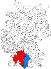
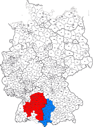
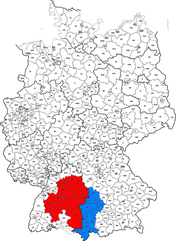
Hrvatski: Karta Švapske unutar Njemačke. Crveni dio pripada državi Baden-Wuerttembergu a plavi Bavarskoj English: Map of Swabia inside of Germany. Red part belong to the state of Baden-Wuerttemberg and blue one to the state of Bavaria |
| Data | (UTC) |
| Orixe | |
| Autoría |
|
| Esta é unha imaxe retocada,en o que significa que a súa versión orixinal foi alterada dixitalmente. Modificacións: added municipalities that belong to Swabia. A orixinal pódese ver aquí: Kfz-Kennzeichen Deutschlands.png. As modificacións realizounas Quahadi.
|
Este ficheiro está licenciado baixo a licenza Creative Commons recoñecemento compartir igual 3.0 sen adaptar.
- Vostede é libre de:
- compartir – copiar, distribuír e difundir a obra
- facer obras derivadas – adaptar a obra
- Baixo as seguintes condicións:
- recoñecemento – Debe indicar a debida atribución de autoría, fornecer unha ligazón á licenza e indicar se se realizaron cambios. Pode facer isto de calquera forma razoable, mais non nunha forma que indique que quen posúe a licenza apoia ou subscribe o seu uso da obra.
- compartir igual – Se altera, transforma ou amplía este contido, debe publicar as súas contribucións baixo a mesma licenza ou outra compatible á orixinal.
Rexistro de cargas orixinal
This image is a derivative work of the following images:
- File:Kfz-Kennzeichen_Deutschlands.png licensed with Cc-by-2.5
- 2008-08-01T12:04:02Z NordNordWest 1351x1844 (440344 Bytes) Kreisreform Sachsen August 2008
- 2007-08-03T08:19:47Z Fremantleboy 1351x1844 (394175 Bytes)
- 2007-08-03T08:18:22Z Fremantleboy 2814x3841 (1138459 Bytes)
- 2007-06-28T16:19:03Z Fremantleboy 1351x1844 (395329 Bytes)
- 2007-05-25T19:13:46Z Fremantleboy 2814x3841 (1145080 Bytes) == Beschreibung == {{Information |Description=Map of German license plates |Source=own work on base of image:Landkreise.svg by [[user:DieBuche]] |Date=24. May 2007 - 24. Mai 2007 |Author=[[user:fremantleboy]] M. Stadthaus |Pe
- 2007-05-24T15:56:15Z Fremantleboy 2814x3841 (1139626 Bytes) {{Information |Description=Map of German license plates |Source=own work - selbst erstellt |Date=24. May 2007 - 24. Mai 2007 |Author=[[user:fremantleboy]] M. Stadthaus |Permission= |other_versions=[Image:Kfz-Kennzeichen_Deuts
- File:KgrWuerttemberg.png licensed with Cc-by-sa-3.0-migrated, GFDL
- 2006-12-02T09:53:33Z Ssch 1524x1968 (122636 Bytes) Corrected the border at Ruchsen (near Möckmühl)
- 2005-10-12T18:27:07Z Ssch 1524x1968 (122557 Bytes) Corrected the border with Hohenzollern - Jettkofen was not an exclave, but connected to Württemberg by a thin strip of land.
- 2005-10-02T10:10:35Z Ssch 1524x1968 (121774 Bytes) Map of the Kingdom of Württemberg from 1810-1945. Drawn by myself.
- File:Bayern_rbschwaben.png licensed with Cc-by-sa-3.0-migrated, GFDL
- 2006-02-24T11:57:21Z Shaqspeare 237x245 (20083 Bytes) Regierungsbezirk Schwaben (Suabia) in Bavaria, South Germany. From German Wikipedia, there described as: Bezirke eingefärbt durch [[:en:User:Ahoerstemeier]] mithilfe der Vorlagen unter [[:en:Wikipedia:WikiProject German di
Uploaded with derivativeFX
Historial do ficheiro
Prema nunha data/hora para ver o ficheiro tal e como estaba nese momento.
| Data/Hora | Miniatura | Dimensións | Usuario | Comentario | |
|---|---|---|---|---|---|
| actual | 19 de xullo de 2011 ás 06:37 | | 1.351 × 1.844 (496 kB) | Quahadi | {{Information |Description={{hr|Karta Švapske unutar Njemačke}}{{en|Map of Swabia inside of Germany}} |Source=*Kfz-Kennzeichen_Deutschlands.png *KgrWuerttemberg.png *[[:File:Bayer |
Uso do ficheiro
A seguinte páxina usa este ficheiro:
Uso global do ficheiro
Os seguintes wikis empregan esta imaxe: