Ficheiro:Map-Francophone World.svg

Tamaño desta vista previa en PNG do ficheiro en formato SVG: 800 × 410 píxeles. Outras resolucións: 320 × 164 píxeles | 640 × 328 píxeles | 1.024 × 524 píxeles | 1.280 × 656 píxeles | 2.560 × 1.311 píxeles | 2.757 × 1.412 píxeles.
Ficheiro orixinal (ficheiro SVG; resolución de 2.757 × 1.412 píxeles; tamaño do ficheiro: 1,47 MB)
| Este ficheiro procede de Wikimedia Commons. A continuación móstrase a información da súa páxina de descrición. Commons é un repositorio libre de ficheiros multimedia. Pode contribuír alí cargando as súas imaxes. |

Any autoconfirmed user can overwrite this file from the same source. Please ensure that overwrites comply with the guideline.
Resumo
| Descrición |
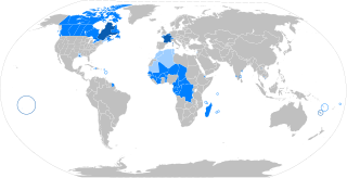
English: The French language in the world
States where French is the majority native language
(Dots: cities with native transmission, typically a minority) States where it is an official or administrative language
States where it is a culturally important language
The following things have been changed from the old "Map-Francophone World.png":
Français : La langue française dans le monde
Langue maternelle
Langue officielle ou administrative
Langue importante et/ou de culture
Les modifications par rapport à l'ancienne version "Map-Francophone World.png" sont :
Español: El idioma francés por el mundo
Lengua materna
Idioma oficial o administrativo
Idioma de importancia cultural
Català: La llengua francesa al món
Llengua materna
Llengua oficial
Segona Llengua Bahasa Indonesia: Bahasa Prancis di dunia
Negara dengan bahasa Prancis sebagai bahasa asli mayoritas
(Titik-titik: kota dengan penutur asli, biasanya minoritas) Negara dengan bahasa Prancis berstatus resmi atau digunakan dalam administrasi
Negara dengan bahasa Prancis berfungsi penting dalam budaya |
| Data | |
| Orixe | Obra propia |
| Autoría | aaker (original PNG file: https://commons.wikimedia.org/wiki/File:New-Map-Francophone_World.PNG ) |
| Outras versións |
|

Licenza
Eu, como posuidor dos dereitos de autor desta obra, pola presente publícoa baixo a seguinte licenza:
Este ficheiro está licenciado baixo a licenza Creative Commons recoñecemento compartir igual 4.0 internacional.
- Vostede é libre de:
- compartir – copiar, distribuír e difundir a obra
- facer obras derivadas – adaptar a obra
- Baixo as seguintes condicións:
- recoñecemento – Debe indicar a debida atribución de autoría, fornecer unha ligazón á licenza e indicar se se realizaron cambios. Pode facer isto de calquera forma razoable, mais non nunha forma que indique que quen posúe a licenza apoia ou subscribe o seu uso da obra.
- compartir igual – Se altera, transforma ou amplía este contido, debe publicar as súas contribucións baixo a mesma licenza ou outra compatible á orixinal.
Historial do ficheiro
Prema nunha data/hora para ver o ficheiro tal e como estaba nese momento.
| Data/Hora | Miniatura | Dimensións | Usuario | Comentario | |
|---|---|---|---|---|---|
| actual | 2 de febreiro de 2025 ás 12:40 | | 2.757 × 1.412 (1,47 MB) | Mastersun25 | update Karabakh |
| 19 de outubro de 2024 ás 22:52 |  | 2.757 × 1.412 (1,47 MB) | IntelloFR | Reverted to version as of 03:15, 13 October 2024 (UTC) | |
| 13 de outubro de 2024 ás 03:16 |  | 2.757 × 1.412 (1,47 MB) | SpinnerLaserzthe2nd | Reverted to version as of 03:09, 13 October 2024 (UTC) Never mind | |
| 13 de outubro de 2024 ás 03:15 |  | 2.757 × 1.412 (1,47 MB) | SpinnerLaserzthe2nd | Changed Mali and Burkina Faso to light blue | |
| 13 de outubro de 2024 ás 03:09 |  | 2.757 × 1.412 (1,47 MB) | SpinnerLaserzthe2nd | At least the Western Togoland part because the HSGF mentioned that 11 percent there speak French in the Western Togoland area | |
| 13 de outubro de 2024 ás 03:01 |  | 2.757 × 1.412 (1,47 MB) | SpinnerLaserzthe2nd | I had emailed the HSGF (which is a group based in Ghana) and apparently, 11 percent of people speak French in Western Togoland | |
| 18 de decembro de 2023 ás 19:24 |  | 2.757 × 1.412 (1,47 MB) | Kwamikagami | french is still the language of govt in Mali -- consistency w USA in English map | |
| 28 de outubro de 2023 ás 01:55 |  | 2.757 × 1.412 (1,47 MB) | Salvabl | Mauritania's color fixed according to what it is stated in the description. | |
| 11 de outubro de 2023 ás 02:08 |  | 2.757 × 1.412 (1,47 MB) | Salvabl | Colors uniformity fixed. | |
| 11 de outubro de 2023 ás 01:56 |  | 2.757 × 1.412 (1,47 MB) | Salvabl | The standard on Wikipedia's world maps is the existence of a border between Morocco and Western Sahara. This is in accordance with the internationally recognized Moroccan borders. Therefore, the fact that French is a widely used language in Morocco is insufficient reason in this case. Either way, the Western Sahara territory could be highlighted if there were more than 20% French speakers within it. |
Uso do ficheiro
As seguintes 2 páxinas usan este ficheiro:
Uso global do ficheiro
Os seguintes wikis empregan esta imaxe:
- Uso en af.wiki.x.io
- Uso en als.wiki.x.io
- Uso en ar.wiki.x.io
- Uso en ar.wikiversity.org
- Uso en ary.wiki.x.io
- Uso en arz.wiki.x.io
- Uso en ast.wiki.x.io
- Uso en azb.wiki.x.io
- Uso en az.wikibooks.org
- Uso en ban.wiki.x.io
- Uso en be-tarask.wiki.x.io
- Uso en beta.wikiversity.org
- Uso en be.wiki.x.io
- Uso en bg.wiki.x.io
- Uso en bh.wiki.x.io
- Uso en bn.wiki.x.io
- Uso en bxr.wiki.x.io
- Uso en ca.wiki.x.io
- Uso en ca.wikiquote.org
- Uso en ce.wiki.x.io
- Uso en cs.wiki.x.io
- Uso en cs.wikiversity.org
- Uso en dag.wiki.x.io
- Uso en da.wiki.x.io
- Uso en da.wikibooks.org
- Uso en de.wiki.x.io
- Uso en de.wikibooks.org
- Uso en de.wikiversity.org
- Uso en de.wikivoyage.org
- Uso en de.wiktionary.org
- Uso en dtp.wiki.x.io
- Uso en el.wikivoyage.org
- Uso en el.wiktionary.org
- Uso en en.wiki.x.io
Ollar o uso global deste ficheiro.