Ficheiro:EremophilaAlpestrisIUCN.svg

Tamaño desta vista previa en PNG do ficheiro en formato SVG: 800 × 566 píxeles. Outras resolucións: 320 × 226 píxeles | 640 × 453 píxeles | 1.024 × 724 píxeles | 1.280 × 905 píxeles | 2.560 × 1.810 píxeles | 1.052 × 744 píxeles.
Ficheiro orixinal (ficheiro SVG; resolución de 1.052 × 744 píxeles; tamaño do ficheiro: 25,95 MB)
| Este ficheiro procede de Wikimedia Commons. A continuación móstrase a información da súa páxina de descrición. Commons é un repositorio libre de ficheiros multimedia. Pode contribuír alí cargando as súas imaxes. |
Resumo
| Descrición |
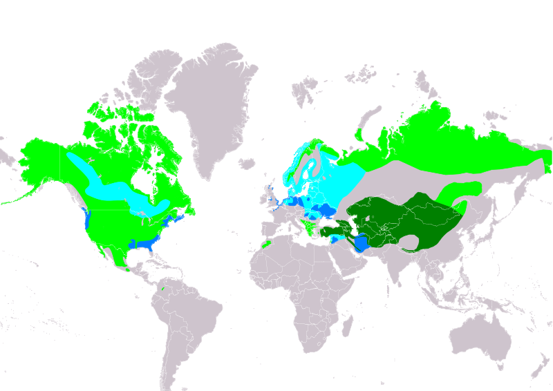
Slovenčina: Mapa rozšírenia druhu uškárik vrchovský Eremophila alpestris podľa IUCN verzia 2021.2 (Zostavil: BirdLife International and Handbook of the Birds of the World (2019) 2019.):
legenda: Hniezdiaci, výskyt v letnom období (#00FF00), Hniezdiaci, celoročný výskyt (#008000), Migrujúci (#00FFFF), Nehniezdiaci (#007FFF) English: Distribution map of Horned Lark Eremophila alpestris according to IUCN version 2021.2 (Compiled by: BirdLife International and Handbook of the Birds of the World (2019) 2019.); key: Legend: Extant, breeding (#00FF00), Extant, resident (#008000), Extant, passage (#00FFFF), Extant, non-breeding (#007FFF) |
| Data | |
| Orixe | Made with Natural Earth. Free vector and raster map data @ naturalearthdata.com. Range map from BirdLife International. 2019. Eremophila alpestris. The IUCN Red List of Threatened Species 2019: e.T22717434A137693170. https://dx.doi.org/10.2305/IUCN.UK.2019-3.RLTS.T22717434A137693170.en. Downloaded on 05 November 2021 as visual indicator of distribution. |
| Autoría | SanoAK: Alexander Kürthy |
Licenza

Este ficheiro está licenciado baixo a licenza Creative Commons recoñecemento compartir igual 3.0 sen adaptar.
Recoñecemento: IUCN Red List of Threatened Species, species assessors and the authors of the spatial data.
- Vostede é libre de:
- compartir – copiar, distribuír e difundir a obra
- facer obras derivadas – adaptar a obra
- Baixo as seguintes condicións:
- recoñecemento – Debe indicar a debida atribución de autoría, fornecer unha ligazón á licenza e indicar se se realizaron cambios. Pode facer isto de calquera forma razoable, mais non nunha forma que indique que quen posúe a licenza apoia ou subscribe o seu uso da obra.
- compartir igual – Se altera, transforma ou amplía este contido, debe publicar as súas contribucións baixo a mesma licenza ou outra compatible á orixinal.
Historial do ficheiro
Prema nunha data/hora para ver o ficheiro tal e como estaba nese momento.
| Data/Hora | Miniatura | Dimensións | Usuario | Comentario | |
|---|---|---|---|---|---|
| actual | 5 de novembro de 2021 ás 20:58 | | 1.052 × 744 (25,95 MB) | SanoAK | Uploaded a work by SanoAK: Alexander Kürthy from Made with Natural Earth. Free vector and raster map data @ naturalearthdata.com. Range map from BirdLife International. 2019. Eremophila alpestris. The IUCN Red List of Threatened Species 2019: e.T22717434A137693170. https://dx.doi.org/10.2305/IUCN.UK.2019-3.RLTS.T22717434A137693170.en. Downloaded on 05 November 2021 as visual indicator of distribution. with UploadWizard |
Uso do ficheiro
A seguinte páxina usa este ficheiro:
Uso global do ficheiro
Os seguintes wikis empregan esta imaxe:
- Uso en ar.wiki.x.io
- Uso en arz.wiki.x.io
- Uso en ast.wiki.x.io
- Uso en bg.wiki.x.io
- Uso en ca.wiki.x.io
- Uso en cs.wiki.x.io
- Uso en cy.wiki.x.io
- Uso en de.wiki.x.io
- Uso en en.wiki.x.io
- Uso en eo.wiki.x.io
- Uso en es.wiki.x.io
- Uso en eu.wiki.x.io
- Uso en fi.wiki.x.io
- Uso en fr.wiki.x.io
- Uso en ga.wiki.x.io
- Uso en hr.wiki.x.io
- Uso en hu.wiki.x.io
- Uso en hy.wiki.x.io
- Uso en id.wiki.x.io
- Uso en nl.wiki.x.io
- Uso en nn.wiki.x.io
- Uso en no.wiki.x.io
- Uso en pt.wiki.x.io
- Uso en ru.wiki.x.io
- Uso en sk.wiki.x.io
- Uso en sv.wiki.x.io
- Uso en uk.wiki.x.io
- Uso en www.wikidata.org
- Uso en zh.wiki.x.io